Share
This article initially appeared in The State of Open Humanitarian Data 2025.
Since 2020, over $100 million has been allocated by the UN Central Emergency Response Fund (CERF) for anticipatory action in eight countries reaching 4 million people with assistance before the worst impacts of a crisis. In 2024, there were 20 active anticipatory action frameworks with an additional 17 frameworks under development for droughts, floods, storms and cholera.
The scaling of anticipatory action programmes has led to an increase in the demand for comprehensive climate data. To bring more awareness to the availability of this data, the HDX Data Grids now include a climate category. It features two sub-categories, with a third to be added in 2025. These are:
- Hazards: Current and historical data about climate hazards such as droughts, floods and storms. This includes observed rainfall, flood extent, vegetation indices, and agricultural hotspots. Storm tracks data was added in early 2025.
- Impact: Current and historical impacts of climate events relating to droughts, floods and storms. This includes indicators such as the number of people affected or displaced, disruptions to populations, destroyed infrastructure, and other impacts such as on agricultural production.
- Forecasts (forthcoming in 2025): Forecast data with projections for riverine floods, seasonal rainfall, and major storms.
These three types of data are essential for anticipatory action analysis, including trigger definition and more general preparedness analysis. We provide two examples below from Cameroon and Mozambique.
Cameroon Floods
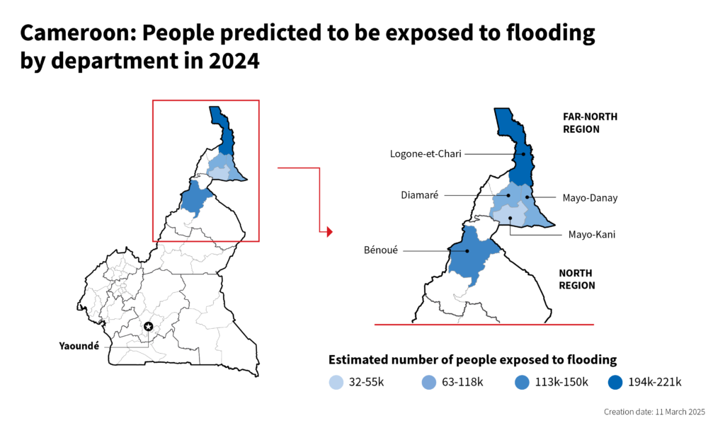
In 2024, the Centre worked with the OCHA Cameroon office to estimate flood exposure ahead of the rainy season and track it in near-real time for river basins in the Far-North Region. This region experiences seasonal flooding, with the peak rainy season occurring in July, August and September each year.
In the months leading up to the season, the Centre’s analysis predicted that around 350,000 people would be exposed to flooding. As the season progressed, over 356,000 people were affected, and the Centre’s updated projections for the rest of the season indicated further flooding, with the severity of a 1-in-20 year event. This analysis supported a timely allocation of $4 million from CERF to help 176,500 affected people in the most vulnerable areas. The Centre made predictions by combining seasonal rainfall forecasts with historical flood extents and population distributions, and used historical flood impact to calibrate the predictions.
Data from each of the climate sub-categories played an important role in the analysis:
- Hazards: Flood extent from FloodScan, overlaid with the population distribution, was used to calculate historical daily flood exposure. (The Floodscan data on HDX only covers the most recent 90 days. For this analysis, we used the full historical record since 1998.)
- Impact: Historical flood impact data was used to calibrate the predictions.
- Forecasts: Seasonal forecasts from the European Centre for Medium-Range Weather Forecasts were used to estimate the severity of the upcoming rainy season, which was then used to estimate the number of people likely to be affected by floods for the upcoming season.

Mozambique Cyclones
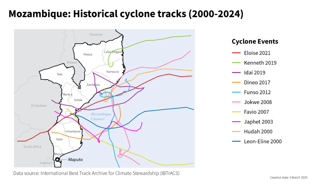
The Centre worked in Mozambique with the OCHA Country Office, the Government and WFP to develop a robust trigger system for the national anticipatory action plan, which is also supported by CERF. Mozambique is regularly impacted by cyclones, especially in the low-lying coastal areas that are home to a majority of the population. Since 2017, some 5 million people have been affected, mostly in the provinces of Zambezia, Nampula and Sofala.
Data from each of the climate sub-categories again played a vital role in the system:
- Hazards: Historical cyclone tracks from the International Best Track Archive for Climate Stewardship (IB-Tracks) provided critical insights into the frequency and intensity of cyclones in Mozambique.
- Impact: Indicators such as the number of people affected (sourced from the Emergency Events Database, published by the Centre for Research on the Epidemiology of Disasters) and historical CERF cyclone allocations were used to evaluate the scale of needs and expected impacts. By combining hazard and impact data, a comprehensive database was developed to link cyclone intensity and frequency with human and financial impacts.
- Forecasts: Historical forecasts from Météo-France La Réunion enabled the simulation and evaluation of trigger performance across different lead times, ensuring the system could respond effectively to future events.
This analysis supported the endorsement of the Mozambique anticipatory action framework in January 2025 by the Humanitarian Country Team and the Emergency Relief Coordinator with a commitment of $6 million pre-arranged funding from CERF. In early March, the trigger for activation was reached and CERF allocated the funds to support over 290,000 people across six coastal provinces with critical supplies.

The year ahead will be particularly challenging due to shrinking funding and a likely decline in the technical capacity of humanitarian organizations to analyze climate data. We will work with partners to bring high-value data on hazards, impacts and forecasts onto HDX, making it more accessible to humanitarians.
Please be in touch with questions or comments at centrehumdata@un.org.